Important Areas of Tanzania and Other African Countries from Space
TANZANIA’S NGORONGORO CRATER, SERENGETI NATIONAL PARK AND OLDUVAI GORGE
Images clickable for enlargement
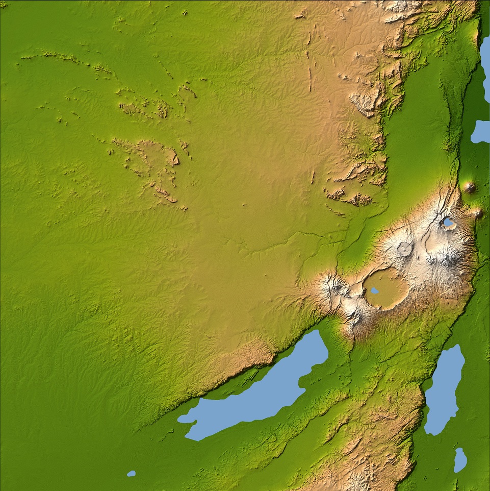
Three striking and important areas of Tanzania in eastern Africa are shown in this color-coded shaded relief image from the Shuttle Radar Topography Mission. The largest circular feature in the center right is the caldera, or central crater, of the extinct volcano Ngorongoro, which is surrounded by smaller volcanoes, all associated with the Great Rift Valley, a geologic fault system that extends for about 4,830 kilometers (2,995 miles) from Syria to central Mozambique.
Ngorongoro’s caldera is 14 miles across at its widest point and is 2,000 feet deep and has a level floor that holds a lake fed by streams running down the caldera wall. It is part of the Ngorongoro Conservation Area and is home to over 75,000 animals. Lakes Eyasi and Manyara south of the crater are also part of the conservation area.
The relatively smooth region in the upper left of the image is the Serengeti National Park, which encompasses the main part of the Serengeti ecosystem, supporting the greatest remaining concentration of plains game in Africa including more than 3,000,000 large mammals. The faint, nearly horizontal line near the center of the image is Olduvai Gorge, made famous by the discovery of remains of the earliest humans known to exist.
Image Credit: NASA
~~~~~~~
TANZANIA’S MOUNT KILIMANJARO AND ITS SHRINKING ICEFIELDS

The Advanced Land Imager on NASA’s Earth Observing-1 satellite image of October 26, 2012, shows some of the same ice fields that are shown in the two photographs below which were taken a month earlier.
The views from the top of Mount Kilimanjaro—a 5,895-meter (19,341-foot) dormant stratovolcano in Tanzania—are as surreal as they are spectacular. After ascending through multiple ecosystems—including cropland, lush rainforest, alpine desert, and a virtual dead zone near the summit—climbers can find themselves peering down on a thick blanket of clouds below that seems to stretch endlessly in the distance.
But in the immediate foreground, ice dominates the view. Kimberly Casey, a glaciologist based at NASA’s Goddard Space Flight Center, was savoring the views from Kilimanjaro’s summit and caldera when she snapped panoramic images (below) of Kilimanjaro’s northern and southern ice fields.
Images clickable for enlargement
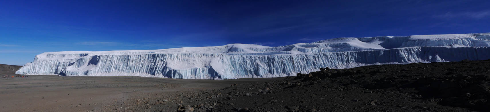
Looking north, a shelf-like block of ice with a sharp vertical cliff sits on an otherwise featureless, sand-covered plateau.
~~~~~~~

In the other direction, a second ice field spills off the edge of the plateau, down the mountain’s southern face.
Despite Mount Kilimanjaro’s location in the tropics, the dry and cold air at the top of the mountain has sustained large quantities of ice for more than 10,000 years.
But trends suggest Kilimanjaro’s peaks may soon be ice-free. Between 1912 and 2011, the mass of ice on the summit decreased by more than 85 percent. Researchers say it’s no longer a question of whether the ice will disappear but when. Estimates vary, but several scientists predict it will be gone by 2060.
Rising air temperatures due to global warming could be contributing to the ice loss, but a number of other factors are just as important, if not more so. An increasingly dry regional atmosphere, for example, is starving the mountain of the fresh snow needed to sustain the ice fields. Drier air is also reducing cloud cover and allowing more solar energy to warm the ice surfaces.
Casey and colleagues noticed yet another ominous sign during their 2012 expedition. The northern ice field, which had been developing a hole since the 1970s, has separated (see “new rift” on annotated image, top). “This was the first year that the northern ice field completely divided into two,” said Casey. “We were able to walk on land—or we could have even ridden a bicycle—directly through the rift.”
Image Credits: NASA Earth Observatory image by Jesse Allen and Robert Simmon, using ALI data from the NASA EO-1 team. Photos by Kimberly Casey. Caption by Adam Voiland.
~~~~~~~
NAMIBIA’S COASTAL DESERT
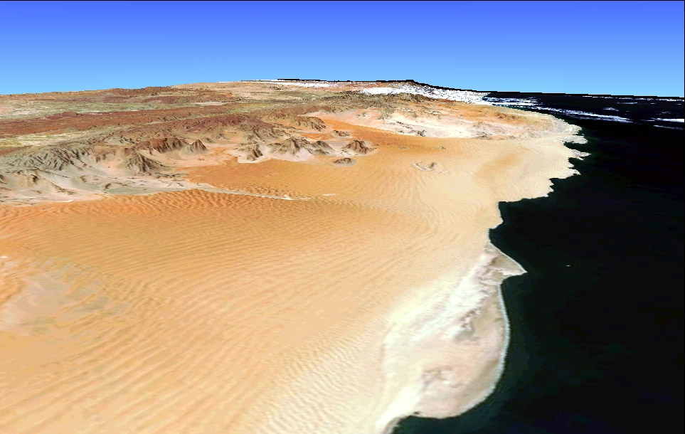
On the southwest coast of Africa, the soft orange sands of Namibia’s coastal desert rise to a rugged interior plateau, with outcroppings of colorful rocks and pale green vegetation. The large coastal desert is one of the oldest in the world, and is caused by a cool ocean current, called the Benguela Current, snaking its way up from the south along southern Africa’s Atlantic Coast. The cold current suppresses rainfall, but contributes to a morning fog that becomes trapped on the surface of some dunes and provides enough moisture for sparse vegetation to grow in some places.
The dunes, pushed up by strong onshore winds, are the highest sand dunes in the world –as high as 1,000 to 1,167 feet in places. Rows of linear sand dunes can be seen as alternating ripples of darker and lighter orange in the center of the image. The dune shapes become more chaotic surrounding the mud plain where a river runs down out of the plateau (left of center), but doesn’t make it to the ocean.
Image Credit: NASA
~~~~~~~
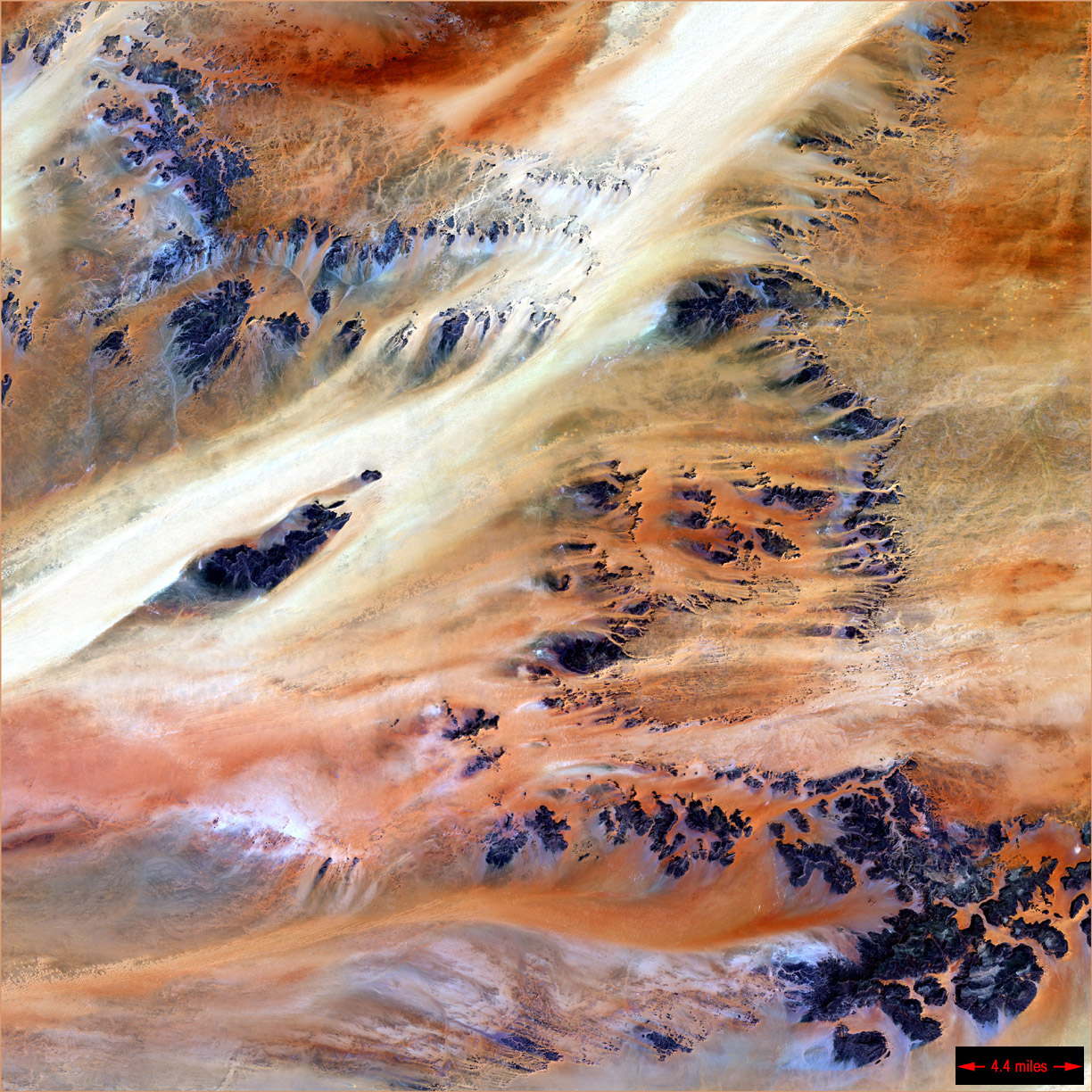
MAURITANIA’S RICHAT STRUCTURE IN THE SAHARA DESERT
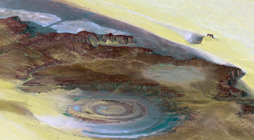
The prominent circular feature, known as the Richat Structure, in the Sahara desert of Mauritania is often noted by astronauts because it forms a conspicuous 30-mile-wide bull’s-eye on the otherwise rather featureless expanse of the desert. Initially mistaken for a possible impact crater, it is now known to be an eroded circular dome of layered sedimentary rocks.
Image Credit: NASA
~~~~~~~
SOUTH AFRICA’S TABLE MOUNTAIN
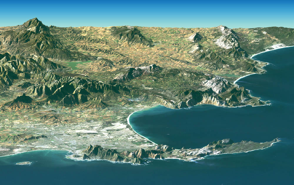
Cape Town and the Cape of Good Hope, South Africa, appear in the foreground of this perspective view. The city center is located at Table Bay (at the lower left), adjacent to Table Mountain, a 1,086-meter (3,563-foot) tall sandstone and granite natural landmark.
Image Credit: NASA/JPL/NGA
~~~~~~~
CHAD’S TERKEZI OASIS IN THE SAHARA DESERT
Dominating the top third of Africa is the Sahara Desert, Earth’s largest band of dry land. Stretching across the Sahara are vast plains of sand and gravel, seas of sand dunes and barren rocky mountains.
Only 10,000 years ago grasses covered the region and mammals such as lions and elephants roamed the land. Now only two percent of the Sahara hosts oases, patches of land usually centered on natural water springs where crops will grow and where nearly two million people live. This image, taken by Landsat 7, is of a colorful and rocky expanse spanning about 50 kilometers near the Terkezi Oasis in Chad.
Image credit: NASA
~~~~~~~
WESTERN SAHARA’S DUST STORM
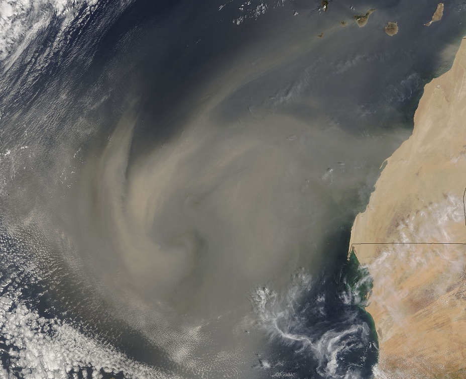
A large, swirling mass of dust, visible on the left portion of the image, is blowing from the Western Sahara into the Atlantic Ocean. The islands at the top of the image are a part of the Canary Islands, a possession of Spain. The landmass on the right side of the image is North Africa, including the territory and country of Western Sahara (currently under the control of Morocco) and Mauritania, respectively. Dust storms occur when very strong winds carry sand from the erg, or sand dune deserts, of the Sahara.
Dust storms are a naturally occurring phenomenon and may “fertilize” the oceans and even the Amazon rain forest by carrying and depositing minerals over great distances. However, they are often exacerbated by agriculture practices that contribute to soil erosion- a process called desertification. Projects are currently underway to remedy this problem by creating barriers to block to movement of sand and by planting vegetation to keep sand in place.
Image Credit: Jeff Schmaltz (NASA Website)
~~~~~~~
EGYPT’S NILE RIVER DELTA AT NIGHT
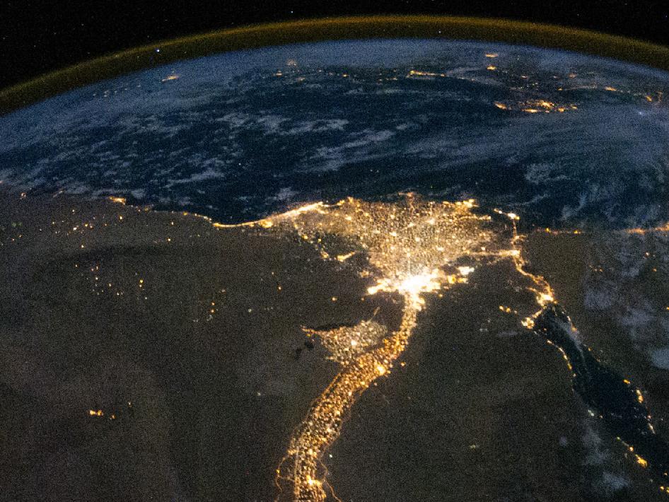
One of the fascinating aspects of viewing Earth at night is how well the lights show the distribution of people. In this view of Egypt, the population is shown to be almost completely concentrated along the Nile Valley, just a small percentage of the country’s land area.
The Nile River and its delta look like a brilliant, long-stemmed flower in this photograph of the southeastern Mediterranean Sea, as seen from the International Space Station. The Cairo metropolitan area forms a particularly bright base of the flower. The smaller cities and towns within the Nile Delta tend to be hard to see amidst the dense agricultural vegetation during the day. However, these settled areas and the connecting roads between them become clearly visible at night. Likewise, urbanized regions and infrastructure along the Nile River becomes apparent.
Scattered blue-grey clouds cover the Mediterranean Sea and the Sinai, while much of northeastern Africa is cloud-free. The thin yellow-brown band tracing the Earth’s curvature at the top of the image is airglow, a faint band of light emission that results from the interaction of atmospheric atoms and molecules with solar radiation at an altitude of approximately 60 miles (100 kilometers).
This astronaut photograph was taken by the Expedition 25 crew on Oct. 28, 2010, with a Nikon D3S digital camera using a 16 mm lens.
Image Credit: NASA
~~~~~~~
NAMIBIA’S PHYTOPLANKTON BLOOM

A flash of blue and green lit the waters off Namibia in early November 2007 as a phytoplankton bloom grew and faded in the Atlantic Ocean. The bloom stretches from north to south along hundreds of miles, although it is brightest in the center of this image. Such blooms are common in the coastal waters off southwest Africa where cold, nutrient-rich currents sweep north from Antarctica and interact with the coastal shelf. At the same time, the easterly trade winds push surface water away from the shore, allowing water from the ocean’s floor to rise to the surface, bringing with it iron and other material. The suffusion of nutrients from both the currents and upwelling water creates an environment where tiny surface-dwelling ocean plants thrive.
Phytoplankton blooms are so abundant off Namibia that their death and decomposition often robs the water of dissolved oxygen. As the plants die, they sink to the ocean floor where bacteria consume them. There is so much plant material that the bacteria use all of the oxygen available in the water before they finish breaking down the plants, creating a dead-zone in the water where fish can’t survive. Anaerobic bacteria, which don’t require oxygen, take over in the decomposition process, releasing sulfur dioxide as a byproduct. The sulfur dioxide interacts with the ocean water to create solid sulfur and hydrogen sulfide, a poisonous gas, which eventually erupts to the surface, sometimes killing fish. Though no eruption is readily apparent in this image, hydrogen sulfide eruptions are often visible in satellite imagery because the solid sulfur colors the water a milky yellow-green.
The Moderate Resolution Imaging Spectroradiometer (MODIS) on NASA’s Aqua satellite captured this image on Nov. 8, 2007.
Image Credit: NASA
Date posted: Friday, February 1, 2013
Date updated: February 1. 2013 (Mount Kilimanjaro and dust-storm images added)
~~~~~~~~~
Please visit http://www.nasa.gov for an astonishing collection of images
Visit the Home Page for a summary and links to all the photo essays on this blog. We welcome feedback/letters from our readers. Please use the LEAVE A REPLY box which appears below. Your feedback may be edited for length and brevity, and is subject to moderation. We are unable to acknowledge unpublished letters.
What magnificent pictures about Creation of Allah!
Stunning images they certainly are and once again a first for Simerg. How many countless will recall trips to Lake Manyara staying a night or two and if lucky watching the tree climbing lions. What a sight. But what about Ngorogoro. That steep descent into the crater. Your stomach in your mouth and when you hit bottom suddenly confronted with a huge elephant who takes no notice of you. S/he is only interested in the water hole to quench his/her thirst but you are definitely worried. Well done Simerg.
Truly peaceful …thank you. “Subhan allah ” comes to mind. Nature is still godly , even if humans are not…